Jade Harvey
Special to the Review
Sounds like science fiction doesn’t it?
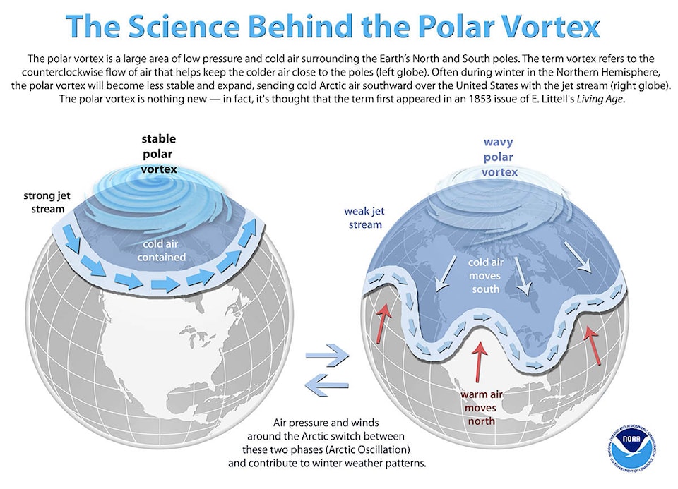
The polar vortex is a large area of low pressure (cloudy, windy) and cold air surrounding the Earth’s two poles.
The term vortex however just refers to the counter-clockwise flow of air that helps keep colder air close to the poles. Normally trapped by a strong jet stream south of it, during the Northern Hemisphere winter the polar vortex often becomes less stable, expands and the jet streams moves outwards with it too. This enables the normally sequestered northerly arctic winds to travel further south into the North American continent.
A ski guide friend of mine, when we were talking about said vortex and my wish to write an article on it, said ‘Oh. Cold weather in Canada. Fascinating. Never would of thought it.’ (I think he learned his scathing sarcasm from me.)
Of course it is something familiar to those that live in Canada, particularly further north or east than our temperate wonderland. It is however a bit special here when it stops snowing and starts gusting in the valley bottoms for several weeks and when the mechanisms driving this shift are poorly understood by most.
My dad and I were chatting over the last week and he was remarking at the weather affecting the UK and Northern Europe right now, a result of the same migration of freezing cold air further south than usual.
His particular amazement though, was reserved for the inability for journalists on mainstream media to communicate effectively the science behind this phenomenon (Spoiler alert: It’s just a part of normal weather cycles). So with his encouragement I attempt to elucidate a bit of science to explain this irritating slump in temperatures and consequently my finger and toe functionality. So, in order to do this, please see the extremely clear diagram below.
The polar vortex is nothing new. It is thought the term first appeared in an 1853 issue of E. Littell’s Living Age. Most of you will have heard of, or know what the jet streams—a mass of fast-moving air (average 160 kilometres per hour) about 10 kilometres above the Earth’s surface which forms at the boundary between different temperature air masses. It can be thought of as a river of sky, flowing, fast, transporting air instead of sediment across the globe.
Those in the know about our snowfall in Revelstoke will know that the position of the jet stream when storms come in is very important in determining the type of precipitation we receive and the strength of wind it comes in with. If the jet stream moves north, we get warmer air from the south the reverse if it moves south. If it splits around an area of high pressure the storms will track along the two river pathways and miss whatever is in the middle. The jet stream is our friend. Mostly. Not so right now. It is waning in strength and allowing its Northern Vortex bully to send it waving up and down into our air space here. Get it together jet stream.
The thing that makes weather forecasting and climatological modelling so difficult is the layer upon layer of short term weather systems that can coincide, exacerbate, modify, weaken or strengthen weather patterns in the short term. A few examples are the El Nino Southern Oscillation (affecting us this year in its average seven year cycle of weakening and reversing trade winds and changing ocean temperatures ), the Arctic Oscillation (we are in a negative phase now and feeling the cold as a result of it) and the North Atlantic oscillation which regulates the jet stream in the Northern Hemisphere through differential air pressure gradients, created between two key spots in the Atlantic ocean.
It would not be possible to talk in depth about these systems in this article, they are already too long and boring, but just know that these cycles interact together above the baseline climate forcing that occurs from our movement around the Sun (google Milkankovitch Cycles) and are all a part of our interconnected globe.
It is fascinating. And hard to understand. The key discussion in the scientific world right now is, how much are the extended and faster melting of ice masses in the Arctic, especially Greenland, impacting on these weather cycles and what will this mean for us, in Revelstoke, particularly in Winters going forward. The jury is still out. I just hope everyone is staying warm, hugging their loved ones and doing some very non-scientific snow dances to get some blower pow back on the forecast.
Jade Harvey is a science lecturer with has a bachelor of science degree.