It was a cold, windy morning when I met Don Pegues for a walk along the Illecillewaet Greenbelt last Thursday morning. The snow from the previous weekend’s snowfall had been blown into drifts along the many trails in the area. The parts that hadn’t been packed down by people were a mix of hard pack and deep, snowy drifts.
I was with Pegues to get a tour of the Greenbelt and the new bridge over the Illecillewaet River that just opened this month.
We met up in Kovach Park, Pegues warm toque tugged down to just above his large glasses. His moustache was showing signs of frost.
Pegues is a lifetime member of the Illecillewaet Greenbelt Society and is the organization’s treasurer. As he puts it, he was asked to join, told he wouldn’t have to do too much, and ended up doing a lot.
“We’ve just been trying to keep things organized as much as possible,” he told me as we joined the main greenbelt trail alongside the park.
The Illecillewaet Greenbelt society was formed in the late-1980s in order to protect the green space along the north bank of the Illecillewaet River. Francis Maltby, a founding member of the society, credited Ruby Knobbs, Doug Powell, Doug Moore and Morris Toporowsky with leading the way on establishing the greenbelt.
“The original concept was they looked at the community and they looked at the fact we had some wonderful natural areas in the community,” Maltby said in an interview. “Key to it was the fact that these areas were habitat and they supported various species. They wanted to have some areas in the community that maintained those functions.”
Getting hold of the land was an ordeal and it required three years of working with various levels of government for the society to get the license of occupation on the 22 acres it now holds.
The society’s initial work involved creating a trail network that could be used at high water. It also went about replacing the trees that had been lost when the Keenleyside Dam was built and the reservoir flooded in 1968.
“Over the course of about 10 years we planted about 10,000 trees,” said Maltby.
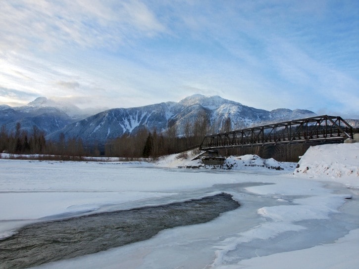
One of the society’s visions at the time was a bridge over the Illecillewaet river and expanding the greenbelt to include the southside of the river. Funding and administrative issues prevented that from becoming a reality until last year, when the City of Revelstoke secured enough grant funding to build the $735,000 structure.
The greenbelt has a different feel to it in the winter. The legions of joggers and dog walkers that venture through the area in summer are much diminished and many of the trails are lost to the snow.
Approaching the bridge with Pegues, it seemed much closer than I expected. Normally I would pass by on my bike and the old railway abutments seemed miles away from town. On this day, we reached the abutments after about 10 minutes of trudging through the snow.
The Mark Kingsbury Memorial Bridge is named after the former president of CMH, who’s foundation made a $100,000 donation to the project in exchange for the name. It was built by Vic Van Isle over the course of the fall and the truss was installed shortly before Christmas.
The bridge won’t have its official opening until the spring but judging by the well-trodden snow along the wooden walkway, it is already seeing substantial use. The bridge was designed to be strong enough to support an ambulance in case the Fourth Street bridge is out of service.
It looks like an old railway bridge. The black steel frame mimics the original CP railway bridge over the river. It is a departure from the suspension bridge design initially envisioned, said Pegues.
“Initially they were looking at a nice airy suspension bridge but then the city, because of the ambulance situation, decided to go with something quite a bit more skookum than what was originally envisioned,” he told me.
On the south bank of the river, the obvious trail peters out. The old railway right-of-way is grown in and it’s not obvious where to go. During high water, much of this land is underwater. Right now, the Illecillewaet River is frozen over, except for one open patch to the east.
The land to the south belongs to a mix of public and private holders and there are plans in the works to create a trail network that would link Arrow Heights to the bridge. Pegues told me he regularly bikes from the river to the airport and if someone is intrepid (and energetic) enough, it’s possible to make it all the way to the Alkokolex River.
There is little doubt the greenbelt has been a success. Recreation use has increased greatly in the area, though it has created problems of more and more trails being created. Francis Maltby expressed concern about the impact of increased use on wildlife.
“The recreational impacts have grown exponentially since the reservoir has come in,” he said. “It has started to affect the ability of some of those areas to support water fowl and some of those other things.”
Still, he’s optimistic that as people become informed, they will be sympathetic to the problem.
“It’s a gem to everybody now,” he said. “People love the area, they appreciate what it’s about.”