Donna Naprstek
Contributor
Editors note: This article is a follow-up to work that was done by the Alpine Club of Canada Columbia Mountains Section in March, 2022.
READ MORE: Retracing explorer’s steps
After months of preparation, three camps were set up for five days along the BC side of the Athabasca Trail over Labor Day weekend. the Alpine Club of Canada Columbia Mountains Section (ACC) members were set to re-open a trail of great significance.
Their mission was to complete the restoration of the Athabasca Pass Heritage Trail that was started the previous summer. To get to their destination, sixteen members of the ACC drove north from Revelstoke on Highway 23, following the shore of the lake, past Mica Dam, then east to Kinbasket Lake, all part of the Columbia River.
The Sprague Bay Recreation Site has a path that leads to a plaque that indicates the location of the Boat Encampment.
A new sign was installed for this ten-minute walk before the members continued to where a barge transported them to the other side of the lake.
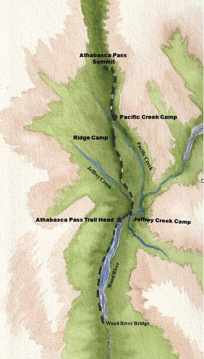
From there they drove on a logging road beside Wood Arm to the Wood River Bridge where a helicopter took them and their gear the remaining eight km to Jeffrey Creek campsite.
The Jeffrey Creek Team stayed there while the Ridge Team and the Pacific Team were dropped off at points along the trail leading up to the Pass.
The members participating that weekend came from Calgary, Rossland, Nelson, Kelowna, Vallican and Revelstoke.
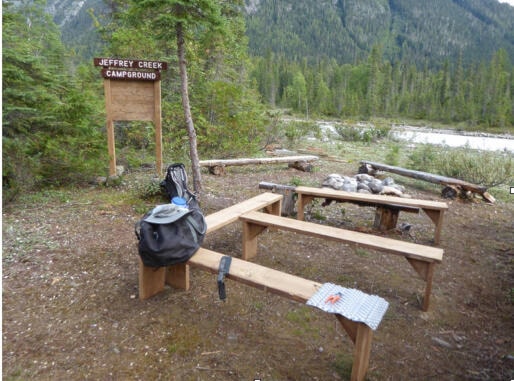
The campsite where Jeffrey Creek meets Wood River is a flat, grassy area and is believed to be the very place where David Thompson and his crew camped on January 11th, 1811.
They continued and wintered at a point between Wood and Canoe Rivers on Kinbasket Lake and called this Boat Encampment.
David Thompson achieved his goal to find a pass through the Rocky Mountains with the help of Thomas, an Iroquois guide, who led the men, horses, and dogs through deep snow.
This opened a gateway to the Columbia River and onto the Pacific Ocean for the fur traders and established an important route for the North West Company.
The old-growth forest on the west side of the Rockies benefits from a warmer climate and a lower elevation than that of the Alberta side. In this mixed woodland, the white bark of the birch trees stands out in sharp contrast to the dark evergreens.
But it was the cedars that supplied David Thompson with building material for the boats they built that winter at Boat Encampment.
David Thompson, who worked for the North West Company, was a British-Canadian cartographer, surveyor and fur trader. Following the Whirlpool River Valley, he discovered the Athabasca Pass through the Rockies, guided by an Iroquois man named Thomas.
The boats would have been lightweight yet durable, to handle the rapids on the Columbia River.
In all of the careful planning done by the expedition leader, safety was considered first. Only the very experienced volunteers were chosen for the type of work that needed to be done.
When the blowdowns were being cleared, chainsawing the deadwood started at the highest point and logs were rolled down to where no one was in danger of being hit. Safety glasses were worn by everyone and helmets and sturdy work gloves protected heads and hands.
Life jackets were available if standing in the fast-running creeks was necessary. In total, 16 km of the trail were cleared and 14 km were brushed.
According to a former RSTBC Regional Recreation Officer, the trail had never been brushed to the pass. The original trail was overgrown and covered in fallen trees for most of its length, it had to be found and marked before the chainsawing began in the Pacific Creek valley.
That required running over 50 km back and forth, through thick brush. Only then was the deadwood removed. This was no easy task for the Ridge Team on the steep slope of La Grande Cote or for the Pacific Team up to the Athabasca Pass and was only possible because of the members’ knowledge of this kind of work.
It was also necessary to build a bridge over Pacific Creek near that camp using a tree that had fallen across it. Back at the Jeffrey Creek camp, a food hang was set up high between trees, benches were constructed, and new signs were installed for the convenience of future hikers.
An already existing immense log lying across Jeffrey Creek was used as a base for the ninety-six-foot bridge.
First, branches were removed, and while two members sat on the log, they used a chainsaw to create a level surface for walking on.
Decking, posts, and supports were then attached to this to give stability to the bridge and a railing to hold on to.
When all of the work was done, members hiked to the summit where a tarn called Committee’s Punch Bowl sits at the Great Divide and drains in two directions: west to the Pacific Ocean and northeast to the Arctic.
Clear skies held for the first part of the weekend but later on as rain clouds moved in, spirits were not dampened in the least and a feeling of pride in the restoration of a heritage trail prevailed right until departure time.
This challenging, remote hike has bright yellow markers to guide the way and is ready to be enjoyed by seasoned adventurists.
The entire enterprise was possible thanks to generous support from the Columbia Basin Trust, Downie Timer, Columbia Mountains Section of ACC, Full Speed Rentals and Great Canadian Tours.
READ MORE: In Review: Acclaimed adventurer completes journey across Canada by canoe
@josh_piercey
josh.piercey@revelstokereview.com
Like us on Facebook and follow us on Twitter.