By Kevin Lavelle
On any early summer evening, a resident of Revelstoke may observe a noticeable glare coming from near the summit of Mt. Cartier. It is, of course, the sun reflecting off the metal roof of a Dominion Forestry Lookout that was constructed on the site in the early 1920s. Little detail is known about those that were involved in the construction and when it was built, but some information has been gathered to help us learn more about those early days of forest fire protection right on our own doorstep.
“In 1880, the Dominion Government granted the Canadian Pacific Railway a strip of land extending twenty miles on each side of the main line in return for building the railway. This was known as the Railway Belt." It included all of Mt. Cartier and then some. It should be noted that the Province of B.C. assumed most forestry related responsibilities with a stroke of the pen on February 27, 1912 that proclaimed into being the Department of Lands – Forests Branch. This agency took over many of the functions of the Dominion Forests Branch, but it wasn’t until 1930 that, “the Railway Belt was turned over to the Provincial Government."
Several forestry lookouts were built by the Dominion Government to fulfill their obligation to protect the timber within the Railway Belt from wildfire. "The Railway Belt, although it was still administered by the Federal Government, actually belonged to the C.P.R. Joss Mountain Lookout (just south of Three Valley Gap) was built in 1921, Eagle Pass Mountain in 1922 and Mara Mountain in 1925." Mt. Cartier was also built in 1922, although work on the long and winding 17-kilometre trail to the summit likely commenced the year before. All the lookouts had high quality standard trails and telephone lines into them. In fact, if you are walking the Mt. Cartier trail today, you will find remnants of the telephone line on the ground in several locations on the upper part of the trail. The telephone line was an overhead type but with no trees in the alpine portion of the trail, the line was supported by large wooden cross supports keeping the line only a few feet off the ground. “Supplies would be taken by pack horse to within a few hundred feet of the summit, from where they were pulled to the top by a winch. Access from there to the lookout site is along a narrow rock ledge across a cliff face." Unfortunately, the Mt. Cartier Forestry Lookout was not utilized for long, as it soon became apparent that due to weather conditions, forest fires were able to get well established long before being detected from such a lofty vantage point. The value of such lookouts diminished as a result and technology would soon give way to more mobile and electronic detection systems that are in use today. It is believed that the Mt. Cartier Forestry Lookout was not officially utilized after 1930. The B.C. Forest Service later chose a location further to the south, on Sproat Mountain, establishing a permanent lookout on the site in 1956.
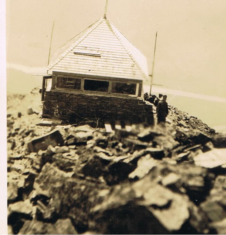
A newspaper article in the Revelstoke Review dated August 14, 1969, talks about members of the Durrand family hiking to the summit and commenting on the condition of the structure. “The old lookout is in remarkably good condition considering that it had been abandoned for over 40 years." The article talks about how Bill Durrand, the grandfather, “worked on the construction of the lookout – the walls being built of rock and mortar, with the window apertures framed in cement." The story also quotes Sam Desimone, who was one of the men who served as lookout man during several fire seasons. Word has it that there were no lightning rods on the lookout, so when a storm approached, the lookout man would descend to the lower timberline cabin, and climb back to the lookout after the storm had passed to report any new wild fires. The Revelstoke Museum and Archives retains a collection of photos that were donated by the Theodore Wadman family of Revelstoke. Theodore was the Dominion Forest Ranger at the time that the Mt. Cartier Forestry Lookout was built and it is believed that he participated in the trail and lookout construction. The photos depict the trail, the summit location conditions shortly after construction of the lookout and amazing panoramic views up and down the Columbia River, all from 1924. The old photo shown here was taken from the summit looking down to the lookout towards the southwest.
While the lookout may have appeared to be in good condition in 1969, the newspaper article goes on to say that, “in recent years it had been struck by lightning which had shattered the roof and has hastened the deterioration of the old building." This situation did not go unnoticed, and in 1974, the site was inspected by then B.C. Forest Service Ranger George Benwell for rehabilitation and repair. A budget for labour and materials was worked up in early 1975 that amounted to over $20,000. In addition to repairs to the lookout, funds were used to re-locate the trail which had become overgrown and lost under snags due to a wildfire on the mountain in the mid 1930’s. Tyke Durrand was instrumental in providing some of the materials and labour involved in restoring the lookout, most notable of which was replacing the rapidly deteriorating roof structure with a brand new metal roof. George and the staff spent the next few summers working at re-locating the trail and upgrading the lookout, work that has withstood the rigours of horrendous weather conditions, as evidenced by an inspection of the site in July, 2011.
In 1987, Canadian Mountain Holidays installed radio equipment to serve the communications network that services the heli and backcountry skiing community that has thrived in this part of the world ever since. Beyond the annual visits for maintenance of this equipment, it is believed that a few hardy souls hike up from the valley bottom every year and either use the lookout as a destination or simply pass it by on their travels further into the backcountry. The year 2012 marks the 100th anniversary of the B.C. Forest Service, and to mark the occasion, Recreation Sites & Trails BC, part of the Ministry of Forests, Lands and Natural Resource Operations, hopes to formally assess the Mt. Cartier Forestry Lookout for maintenance and repairs that will be implemented to preserve this historical lookout for many years to come. The lookout is a testament to the development of early fire detection and suppression systems in the province of B.C. While the original use of the structure has long since waned, it is hoped that it remains intact and in good condition for other important recreational and communications uses for now and well into the future.