In 1940, when the Big Bend Highway was opened, it was hailed as the next great thing. Newspaper articles hailed its smooth roads, with easy curves and no steep grades. It was a modern highway that accessed some of the most spectacular scenery around, and the province actively promoted that fact. It passed by Boat Encampment, the historic trading post where David Thompson began mapping the Columbia River in 1811. Most importantly, it completed the highway link between Alberta and the rest of British Columbia.
"The 65-mile route we travelled over yesterday was practically sea-level road. There are no hazards, hills or mountains to climb," wrote one journalist in the News Herald while the highway was still under construction in the 1930s.
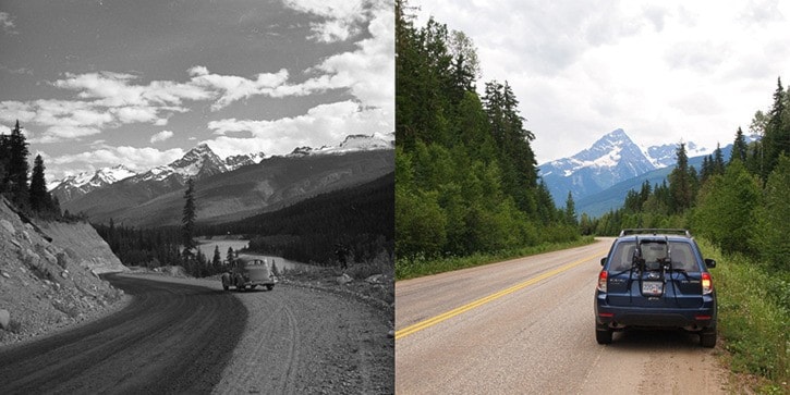
A.W. Lundell, the publisher of the Revelstoke Review, wrote: "In fact, every foot of the 180 miles between Revelstoke and Golden epitomizes the very latest in highway construction."
Twenty-two years later the Trans-Canada Highway was opened through Rogers Pass and people couldn’t be happier. The Big Bend Highway was never paved, and it was never kept open in winter because it was too expensive to plow. It was rough and so dusty the trees were a dull grey, according to one article.
"Goodbye to the Big Bend," said the headline of an article by Donovan Clemson in the magazine B.C. Motorist. "'And good riddance too,' I expect many motorists might exclaim."
The highway was paved to facilitate construction of the Mica Dam and rerouted when Lake Revelstoke was filled up behind the Revelstoke Dam. Before then, it followed a very different landscape. From the Big Bend to the Big Eddy, it passed through a series of seven rapids – Gordon Rapids, 12 Mile Rapids, Dalles des Morts (Death Rapids, where seven French voyageurs were wrecked and only six survived in 1817), Priest Rapids, 18 Mile Rapids, Steamboat Rapids and Little Dalles Canyon (also known as Revelstoke Canyon, where the Revelstoke Dam is today).
Today, all that is flooded. Highway 23 North, as its now known, is 150-kilometres of paved bliss, with almost no traffic to speak of and amazing views most of the way. It’s primary purpose is to get to and from Mica Dam, but it also accesses a number of recreation sites and trails, including world-class rock climbing, mountain biking, hiking and ATVing. At pretty much any point you can turn east down a logging road and venture off into the Selkirk Mountains – good 4WD or an off-road vehicle is recommended. Or turn left to find a secret campsite that hopefully hasn’t been taken yet.
It's a joy to drive, with the views dominated by the Jordan Range, with its many glaciers and Frenchman's Cap, which is nicknamed the Matterhorn of the Monashees and is one of the area's signature peaks.
Here's your guide to the highway to nowhere, by kilometer from Revelstoke:
0: The Frontier Restaurant and motel. Stop for breakfast, lunch or dinner. There’s an Indian buffet on Fridays, and Mexican buffet on Sundays.
4: Turn off here for the BC Interior Forestry Museum and the Revelstoke Dam Visitor Centre and learn about two of the engines of the local economy.
8: The Lake Revelstoke Boat Launch. Put your boat in the water here and take off to experience the area by water. It’s about 120 kilometres of open water to Mica.
12: Waterworld, one of Revelstoke’s most unique rock climbing areas, can be found here. Either boat in from below or rappel in from the top to access a number of different climbs on three separate walls.
17: Martha Creek Provincial Park nearly doubled the number of campsites last fall, expanding to 46 from 25. It also has a sandy beach, playground, boat launch and more. It’s the closest campground to Revelstoke.
20: Sale Mountain turnoff. Look for the road to the east that will take you up more 1,500 metres to the alpine for some great hiking or an epic mountain bike descent all the way to the valley below.
25: Wadey camground. This is the author’s pick for the most peaceful campground on the lake. It has 30 sites tucked in the forest alongside Lake Revelstoke. It’s right below the beautiful, curving Laforme Creek Bridge.
35: Carnes Creek campground is actually two different ones located north and south of Carnes Creek. There’s also a hiking trail that follows the north side of Carnes Creek –look for the turnoff just north of the bridge.
50: Keystone-Standard Basin. This is one of the great scenic trails around. It’s 11 kilometres to the cabin and you can bike or hike through beautiful alpine meadows. Look for the Keystone Creek FSR on your right.
91: The Goldstream River enters Lake Revelstoke here. There’s some great rapids in parts, and there’s a long section that makes for a great canoe trip, but the put in and take out are both difficult to access, so be careful before trusting your Backcountry Map Book.
140: Mica Creek village, home to the workers at the Mica Dam, and a few others. It’s the most civilized spot around, though there really isn’t much here.
142: Fred Laing Ridge. Just past Mica Creek is a rough forestry road that will take you to a radio tower and the start of a short hiking trail that leads to incredible views of the Monashees, Selkirks, Rockies and the massive Kinbasket Reservoir.
150: The Mica Dam. At 242-metres high, it’s one of the world’s tallest earth-filled dams and can generate 1,805 megawatts of power. That number will increase when turbines 5 and 6 go online in the next few years.