A flood of letters opposing proposed land-use changes in Arrow Heights is a result of a "a mis-understanding over what zoning and re-zoning and land-use are," city planning director John Guenther told council at its meeting on Tuesday.
Councillors were presented with the letters in their council agenda for the meeting of Aug. 9. They were responding to proposed changes in the draft Unified Development Bylaw (UDB) that presents the possibility of multi-storey apartments across from the hospital, commercial development at Airport Way and Nichol Road and other changes to the neighbourhood. They wrote how it would increase traffic, change the quiet character of Arrow Heights and detract from business downtown.
"It is not appropriate to now drastically change the nature of the neighbor-hood which is already well established," wrote Tanya Kemprud and Don Munroe in their letter to council.
Some of the letters also questioned the July 31 deadline for public comments – saying it was in the middle of summer when many people were away.
"Are you trying to slide this through without too much debate or discussion from local residents?" asked Carol and Craig Madlung in their letter. "I believe that is the case. I have spoke personally to many residents and this has come as a surprise to about 90 per cent ofthe residents I spoke to."
However, at council, Guenther pointed out the process has been going on for more than a year and several public meetings were held and the website revelstokeudb.com was set up. As process has been written about numerous times in this newspaper.
Still, a public hearing in late-June was sparsely attended.
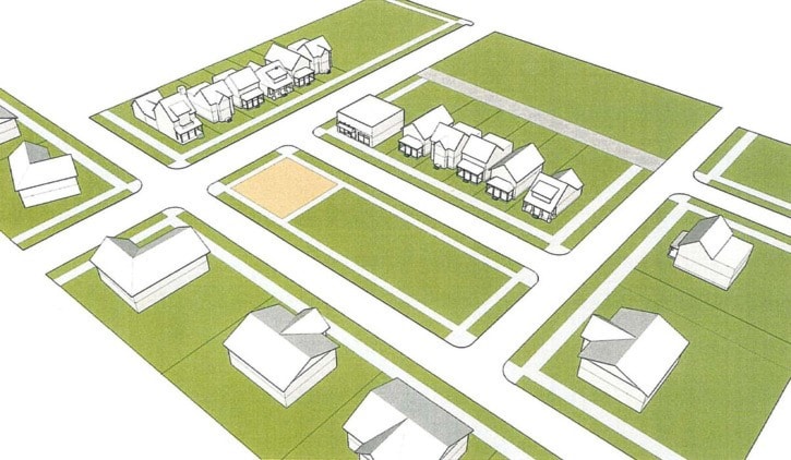
Guenther said the backlash could be attributed to conceptual drawings in the appendix of the draft land-use plan that show commercial development and apartment buildings in Arrow Heights.
In a follow-up interview, he explained the differences. In a nut shell, a land-use plan prescribes the density and character of a neighbourhood and what kind of uses could be permitted.
"The proposed draft land use changes begin to mix uses, in some cases, and starts to outline density," he said. "The land use map is an important tool for identifying existing conditions and for working toward a vision for the community."
Still, all zoning would remain the same and if someone wanted to set up a store in an area of Arrow Heights that the land-use plan permitted, they would still need to submit a re-zoning application and go through a public hearing before it could be approved.
Guenther said the letters and other comments the planning department received would be taken into account and a staff report will be presented to council.
"The staff report that will come back will be recommending we move ahead in a couple of places, make some alterations in a couple of places and make some severe changes in a couple of places and then recommending first and second reading of the bylaw and then setting a public hearing," he said.
***
Secondary suites here to stay
A motion by councillor Tony Scarcella to stop permitting secondary suites in all single-family residential (R1) zones was voted down by the rest council.
Scarcella, responding to a letter from James and Gwen Eadie that complained about a secondary suite being attached on his neighbours Nichol Road home, said secondary suites were devaluing people's homes.
"This building looks like a completely separate building from her existing home but the building bylaw department considers it to be part of her existing home and calls the whole complex a single dwelling family home," the Eadies wrote. "It gives no consideration what so ever to the design and shape of her existing house or to the design and shape of the surrounding neighborhood homes."
They asked that a hold be put on the construction of the neighbour's building and objected to the construction of secondary suits in R1 zones. Scarcella took up their cause in council on the latter.
"Those people work all their life to have assets and now we tell them their house is not worth as much as it should be," he said. "I'm tired to see all this destroying Revelstoke."
Secondary suites have long been permitted in R2 and R3 zones but were only legally allowed in R1 zones (which include much of Arrow Heights and Clearview Heights and parts of Columbia Park) starting last year.
City planning director John Guenther said the addition in question was allowed under the city's development regulations regardless of whether it was a secondary suite or not. He added that the new land-use amendments being worked on would give the city more control over building form, potentially preventing additions like the ones the Eadies opposed.
No one else felt the same as Scarcella and his motion was opposed by all four other councillors present (Phil Welock was absent from the meeting).
***
Support given to snowmobile fight against caribou closures
Council agreed to support the local snowmobiling organizations fight against new caribou closures
The vote was 3-2 in favour of sending the letter, with councillors Scarcella, Peter Frew and Steve Bender voting in favour and councillors Chris Johnston and Antoinette Halberstadt voting against the motion.
Andrea Threatful, the executive director of the Snowmobile Revelstoke Society, said the closures were not done with proper consultation.
"We are looking to resume negotiations with government and to provide alternative workable solutions," she told council.
Couns, Halberstadt and Johnston both said council should get information from both sides before lending support to anyone.
***
City bike network approved
A bike network through Revelstoke from the resort to the Big Eddy was given the official stamp of approval by city council at its meeting Tuesday.
The route would start at the resort and head north on Camozzi Road, west on Nichol Road, north on Airport Way, onto Fourth Street, Third Street, Douglas Street, over the Big Eddy Bridge, along Big Eddy Road and south along Highway 23.
The route will see marked bike lanes painted on Highway 23 South, Big Eddy Road, Airport Way, Nichol Road and Camozzi Road. The remainder would see shared lane markings placed on the road.
For more on the new route, read this article from the July 20 issue of the Times Review.
***
Repairs ordered on two dilapidated homes
Two home owners will have to perform substantial renovations of their homes after they were found in serious violation of the building code.
In the case of one house, an abandoned home at 604 Fourth Street East, city council voted to give owner Ronald Hynds 30 days to demolish an overhanging deck that was deemed at risk of collapse.
In the second case, the heritage home at 714 Mackenzie Avenue was found in significant disrepair. The house, which used to belong to the city superintendent, was found to have missing support beams, walls, plumbing and electrical work; and fire damage, amongst other issues.
Owner John Skrypnyk was given 45 days to address the problems.