You're out in backcountry skiing, standing at the top of your line, ready to drop in. The danger rating is considerable so you ease into the slope, placing a big ski cut to see how the snowpack reacts.
Boom! A small slab avalanche releases below you. You watch it slide away, heart pumping, thankful you didn't get caught. A look at the fracture line shows it likely released on that December 17 surface hoar layer the avalanche bulletin warned about.
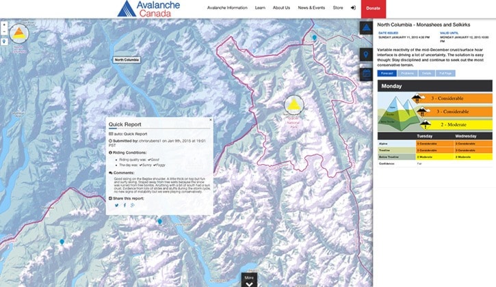
You whip out your smart phone, turn it on, take a picture, fire up your Avalanche Canada app and within moments you're sending in a report to the new Mountain Information Network — a web-based tool introduced this season by Avalanche Canada to help backcountry users share information.
"We've created a database and mobile app and web app that people can use to input data from the field that they see, very similar to the way professionals do it," said Karl Klassen, the public avalanche warning service manager for Avalanche Canada. "It's not as in depth or as detailed as a pro system, but it's more or less the same idea — try to mine the data from the public that's out in the mountains every day."
The Mountain Information Network has existed in different forms in previous years. You used to be able to submit an incident report through the Canadian Avalanche Centre website (the CAC is now known as Avalanche Canada). Last year, Avalanche Canada introduced a mobile app that allowed you to upload a photo and brief text description online.
The new program still allows for users to upload photos and a text description of what they experienced, but it also features drop-down menus that allow users to describe the snow, avalanche and weather conditions they witnessed.
"The platform is much more stable and robust than it was before. The database is much more complete," said Klassen.

Inputting information to the network is fairly simple. You can do so on your phone using the Avalanche Canada app, or online at avalanche.ca. The program allows you to give a title to the report and set the date and time. If you're inputting from the field, it can find your location, otherwise you can pinpoint it on a map. There's also drop-down menus allowing you to select riding and avalanche conditions.
Under the former, you can indicate snow quality (powder, heavy, wet, wind affected, etc…), what kind of
slopes you rode (alpine, cut blocks, open trees, steep slopes, etc…) and what slopes you avoided. You can also select from several weather options such as cloudy, cold, foggy, stormy, sunny.
A second set of menus lets you describe the avalanche conditions: were their slabs? Did you hear any whumphing? Was there any new snow, wind loading or rising temperatures?
The information is then uploaded to the network, where it is displayed on avalanche.ca. Other users can view your report by clicking on the blue dot.
"Hopefully everybody makes better decisions with that information," said Klassen.
The network is still in its initial stages. There are plans in the future to make it even more robust, so a highly-trained recreationist or professional can input more detailed snowpack information, said Klassen.
Avalanche Canada is currently seeking funding to move into the next phase. About $190,000 was spent developing the current app, said Klassen. Funding came from TECTERRA, a Calgary-based non-profit that supports geomatics-based technologies.
"The long-term plan is to build it out into a much more detailed system that allows people to exchange information right down to temperature and wind, avalanche observations, measurements of avalanche, snowpack information," said Klassen. "Eventually, the long, long term is to build a trip planning tool that allows people to put information together and use the app to make better decisions right in the field where they are."