Two weeks ago, a week before the rains that left much of southern Alberta and parts of southeastern British Columbia flooded, Simon Hunt took part in a conference call warning that a major weather system was approaching Revelstoke.
"I was contacted by Emergency Management British Columbia and they had been informed by Environment Canada that a large upper low pressure system that was situated off the coast of Oregon – they were forecasting with high confidence that it was going to head inland across the 49th parallel," Hunt told me. "At first they were forecasting over 100 millimetres. It could have been more – 100 to 140 millimetres."
More conference calls were held as the system approached. Eventually it was realized the system was tracking south and Revelstoke would be spared the worst of the rain. Still, when it did arrive on Wednesday, June 26, it brought with it about 50 millimetres of rain to the area.
Still, in the week between the first reports and the arrival of the storm, Hunt, who is the Emergency Plan Coordinator for Revelstoke and Area B, started contacting people to prepare. He notified the City of Revelstoke so the department of public works would know to check on the creeks around the city and make sure there were no issues with the dykes around the city.
"The River Forecast Centre was predicting that small creeks were going to be most affected, just like what happened last June when the Trans-Canada got closed between here and Sicamous," Hunt said. "Our large tributaries weren't going to be significantly impacted. The fact we have BC Hydro and our rivers are regulated means we have amazing capacity to manage water and prevent flooding."
***
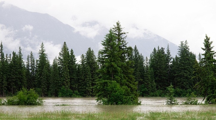
Prior to the construction of the dams, Revelstoke used to experience periodic flooding. A 2008 report on the Big Eddy dykes shed light on some past floods. In 1894, the Columbia River reached an elevation of about 441 metres, flooding parts of the city and large areas of farmland in the area. A 1948 flood reached a similar level, and a 1961 flood was just a bit lower.
In 1948, water flowed across large sections of the Big Eddy but by 1961, several dykes had been built, preventing a repeat of the previous experience – though several basements were flooded. Pumping stations were installed to prevent groundwater from rising above 438.4 metres.
The B.C. government produces floodplain maps based on the area that can be expected to flood once every 200 years. For Revelstoke, the biggest floods are expected to reach an elevation of 442.25 metres – above the highest levels experienced in 1894. Without any protection in place, large sections of Southside and the Big Eddy would be flooded, but a system of dykes and pumps are in place to prevent that from happening; the Greenbelt pathway and Big Eddy pathway are both built on the dykes.
Revelstoke also benefits from water control by BC Hydro on the Columbia River and, as Hunt put it, the Illecillewaet River is capable of channelling a lot of water. Last week I went whitewater rafting with Apex Rafting and our guide said the water flow was at about 200 cubic-metres per second – about half the peak level it reached last June.
 Simon Hunt. Photo by Aaron Orlando/Revelstoke Times Review
"From a flood point of view we're really well situated. We're used to seeing lots of rain," said Hunt. "We have an excellent system of dykes and pumps. Our major river, the Columbia, is regulated and that's humungous. That's why (last year) everywhere flooded but us, because they were able to manage our water so well."
***
So, what would happen if there was a flood? Like in any emergency situation, an Emergency Operations Centre would be set up at the airport; the centre can be made mobile if necessary.
Hunt showed up at my office with a big binder that contained the Revelstoke and Area Emergency Response Management Plan. He said there are copies spread throughout the city, though I couldn't find it online. The plan details what would be done in case of an emergency. The actual response would depend on the situation on the ground.
Hunt would co-ordinate with various agencies, including BC Hydro, Parks Canada, the Ministry of Transportation, the City of Revelstoke, and the Columbia Shuswap Regional District. He would speak to a hydrologist to get an idea of what would happen to the rivers and creeks in the area. If necessary, an evacuation centre would be set up by Emergency Social Services either at the community or one of the schools in case people need to be evacuated from their homes.
The fire department, BC Ambulance and the RCMP would be called on to provide emergency response. If necessary, Search and Rescue would provide extra support. Heavy machinery would be deployed to help manage any flooding.
"We look at emergency management as a web where the incident is in the middle and you have lots of strands going out," said Hunt. "Even if you lose a couple of strands, you have a strong network."
He said the situation leading up to the rains last week was a good experience because it allowed him to get in touch with many of the agencies that would be involved in a response. He is interested in meeting with anyone who can provide information on any emergency scenario.
"This was a really good experience for me. I've only been doing this job for six months," he said. "The most important part of emergency management is knowing your team, so this gave me the opportunity to bring the team together."
To contact Simon Hunt regarding emergency response planning, call 250-837-8146 or e-mail epc@revelstoke.ca.