City and provincial officials are investigating the impact of a massive water surge down the Illecillewaet River earlier this week.
The river surged late on Tuesday, Oct. 14, when a landslide crashed into Woolsey Creek, which flows into the river near the eastern boundary of Mount Revelstoke National Park.
The slide caused water flows to increase almost six-fold in the span of less than two hours. According to hydrometric data collected by Environment Canada, flows went from 34 cubic-metres per second at 7:45 p.m. all the way to 185 cubic-metres per second at 9:20 p.m. Flows didn’t return to normal until late the following morning.
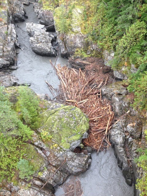
The surge wreaked havoc on the river, sending trees and other debris downstream. The water level in town briefly rose by about 60 centimetres. Piles of wood can be seen scattered along the Illecillewaet River by the Greenbelt trails. Elsewhere, a big log jam formed at the junction of Woolsey Creek and the Illecillewaet River and there is also a log jam in the Illecillewaet box canyon just east of town.
Much of the debris is expected to be flushed out of the river during the spring freshet but there are still concerns.
Mike Thomas, the city’s director of engineer, said in an e-mail he spent most of Wednesday looking for the cause and impact of the surge. He forwarded portions of an e-mail from Jeff Ferguson, a local official with the Ministry of Transportation.
“The debris flood in the Illecillewaet River yesterday was most likely the result of a glacier lake outburst flood originating from an unnamed glacier at the head of Clabon Creek (a tributary of Woolsey Creek),” wrote Ferguson. “It resulted in a surge of water that brought coarse woody debris and sediment into the Woolsey Creek and ultimately the Illecillewaet River.”
Check out the slideshow for photos from the effect of the landslide and subsequent water surge. The story continues below.
Thomas said Emergency Management BC, the Ministry of the Environment, CP Rail, Ministry of Transportation & Infrastructure and Parks Canada were notified. Rob Girard, the city’s emergency coordinator was also informed.
Initial investigation shows the city’s Greely Creek water source was not impacted. The water main to Arrow Heights, which runs under the Illecillewaet and was recently exposed, was not damaged and is now covered by fresh debris. The city will be inspecting the Illecillewaet dyke and bridges along the river for damage in the coming weeks.
The biggest concern, said Thomas, is the log jam at the box canyon, which has been identified as a risk and may need to be removed before winter.
Thomas said an update will be provided to council on Tuesday, Oct. 28.
The Times Review was unable to reach other agencies to see if there were any other impacts before press time.
The section of river that surged is a popular kayaking route and is used by Apex Rafting for their whitewater rafting trips. Debbie and Ralph Koerber, the owners of Apex, went to inspect the raft run on Friday.
“There was a much larger slide on the upper Illy two years ago,” Debbie said in an e-mail. “We expected worse from that one. The river has a way of cleaning itself out. We’ll just have to wait and see but we don’t anticipate any problems.”