Starting Monday, April 23 Revelstoke residents will be asked to provide input on new bike routes proposed for the city.
The plans for a commuter bike route from the Illecillewaet River Bridge to the Big Eddy Bridge have been in development for some time. City council will consider a series of reports on the bike plans at its April 24 meeting. They include a report from the city's engineering director and the city planning director.
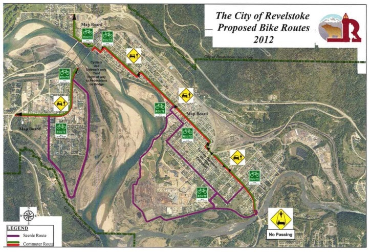
The bike routes would include a main commuter route down Third, Fourth, Douglas and Charles. Secondary recreational routes are proposed, such as along the pathway leading from Centennial Park to the Illecillewaet River Bridge, and another leading along Eighth Street East.
The report focuses on options for several problematic areas along the route. For example, the troublesome and confusing intersection at Fourth Street and Victoria Road is flagged for special concern. Options include painted bike boxes and lanes marked with thick "elephant's feet" paint lines. It's also proposed inexperienced cyclists be prompted to dismount and cross Fourth at the crosswalk.
Likewise, there's debate about what to do on the Big Eddy Bridge. The plan favours having cyclists use the separated sidewalk over the bridge and dismounting when they encounter a pedestrian.
On the Illecillewaet River Bridge, the plan is to post "no passing cyclists" signs as cars passing fast-moving cyclists on the narrow bridge remains an issue.
In his report, City of Revelstoke engineering director Brian Mallett notes there will be costs for annual maintenance of the new road paint and road signs but that final figure is unknown. It will be available once the final route is brought back to city council for final approval.
The bike route will include a combination of separated bike lanes painted on the ground, and "sharrows" which are mixed-use bike/car lanes. The latter are utilized where the road isn't wide enough for a vehicle and bike lane.
The plan also outlines plans for a lane through the Big Eddy, and future plans to formalize the route all the way from Revelstoke Mountain Resort to the Mount Macpherson biking network.
No curbside parking will be eliminated in the plan.
Planning documents included in the report trace the history of the plan to build bike lanes.
Maps, information, comment forms and other details will be made available on the City of Revelstoke website and at the Revelstoke Community Centre from April 23 to May 10.
To view the full plans, see items 8a and 8b in the April 24 city council agenda.