Shovelling. Working as an avalanche technician in Glacier National Park requires lots of it. Shoveling out the cabin, and digging snow pits.
"We shovel a lot," says Danyelle Magnan as she and her colleague Chris Gooliaff dig a full snow pit on Mount Fidelity. I offer to help, but I don't push the matter when they decline the offer, and take pictures instead. The pit is 1.5 metres deep and two metres wide — big enough so they can get a good read on the developing snowpack.
Their big concern is a weak layer that was buried on January 4. It consists of a mix of surface hoar, crusts and facets, depending on where you are and which way the slops is facing. They were directed to see how it was reacting in advance of the big storm that was forecast to arrive that day.
"The slab above it is just really developing now," said Magnan.
I joined Magnan, Gooliaff, Ian Gale and Dean Flick on a visit to Mount Fidelity last Thursday, Jan. 21. Gooliaff is a visitor safety officer while the others are avalanche technicians. Also with us was Allison Fleischer, the new external relations manager for Mount Revelstoke and Glacier National Parks.
Mount Fidelity is closed to the public all winter. It's been used as a snow monitoring site since the early 1960s, when the Trans-Canada Highway was built through Glacier National Park. For decades, an avalanche technician would live in a cabin on the mountain and would make daily weather and snow observations and radio them down to the forecasters at Rogers Pass.
Now, the avalanche team accesses the site by snow cat on a road that winds its way up the mountain. The cabin still exists, along with some of the historic equipment. In a corner rests a massive saw they once used for snow profiles until someone realized it would be easier to cut the snow with a thin rope.
The snow study site is located at about 1,905 metres elevation and was likely established for the easy access it provides to a variety of elevations and aspects.
"We can get to the treeline and alpine safely in whatever weather, which is pretty key for our teams," said Magnan.
The other benefit is there's a historical snowpack record dating back 50 years, which is a valuable resource for the avalanche forecasters and researchers.
Significantly, it's unskied, so the snow isn't impacted by skier traffic.
"It's becoming increasingly difficult to find areas where we can get snowpack information that's safe to access, you can access in a reasonable amount of time, and get that information that hasn't been affected by people schralping everything," said Magnan.
***

PHOTO: Glacier National Park avalanche technician Ian Gale measures the trace amount of snow that fell the previous night at the Mount Fidelity snow study site on Thursday, Jan. 21.
The typical day for the avalanche team begins at 7 a.m. at the Rogers Pass Centre. The first one in checks the weather, the second does a safety briefing, and one of them will write that day's avalanche bulletin. They meet to discuss the day's objectives and head out. That could mean a visit to Mount Fidelity, or a trip to somewhere else in the park to get additional snowpack information. Recently, teams went up to the Dome and to Little Sifton to dig pits and collect data.
I met the team at the base of Mount Fidelity and we drove up the road in a cat to the snow study site. Light flurries fell from the sky and the question on everyone's mind was when the big storm would hit the area. Depending on which forecast you believed, more than 40 centimetres of snow might fall over the course of the next day.
"That's our big concern, is that system coming in," said Magnan. "There's a bunch of different weather forecasts, and if you go by the ones that are most optimistic snow-wise you can get a pretty significant load in the next 24–48 hours and it definitely has the potential to produce some pretty big avalanches and for things to get touchy for skiers."
Upon arrival, they checked the weather data. There are stakes set up that measure 24 hour, 48 hour and storm snow totals; another one keeps track of the height of the snow over the winter. There's three elevated towers with instruments that measure snow and precipitation.
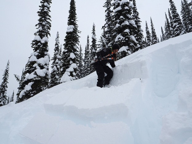
The data is radioed down to the forecaster at Rogers Pass and the teams headed out to do full snow profiles. Flick and Gale strapped on their skis and skinned over to a north facing slope while I joined Magnan and Gooliaff to drive slightly downhill in the cat to dig a pit on an east aspect. We stopped at a spot called Jim Bay's corner; each switchback on the road is named for where someone once got the cat stuck.
***

PHOTO: Left: Magnan looks on while visitor safety officer Chris Gooliaff performs a compression test.
A full profile usually involves digging to ground, which here is 170 centimetres below the surface of the snow. However, this winter the mid and lower snowpack has consolidated and lower layers are not a concern so they only dig down 1.5 metres. The January 4 layer, about 40 centimetres down, is what they're looking at.
The profile requires conducting three compression tests, two shovel shear tests and one Rutschblock test. Each tests the weak layers in varying ways. The Rustchblock test is the most involved. In it, a skier will step on an isolated block of snow and provide increasing amounts of pressure until it fails.
Gooliaff conducted the compression tests while Magnan examined the layers in the snow pack. She marked them in the snow, measure their depths, looked at the temperature of the snow in each layer, and looked at the density of the snow.
Magnan had the honour of conducting the Rutschblock test. She strapped on her skis and climbed to the top of the slope. She stepped on the block and nothing happened. Then, she bent her knees and the whole block collapsed — the sign a slab had developed and it could propagate. "Last week there was no slab above (the Jan. 4 layer). You might get it to fail, but the snow above was fluff," said Magnan. "What we see today confirms it's turning into a slab."
Slabs are the big danger in the avalanche world and are what causes the really big avalanches that bury people — and roads.
When Gale and Flick radioed in their result, they reported little reactivity. That makes it more challenging when writing the avalanche bulletin, said Magnan. "It makes it harder to communicate, but what we saw was in that realm of skier triggerabilty, the potential to trigger a slab avalanche that could bury a person is there," she said. "We're already thinking about tomorrow's bulletin today, and tomorrow you'll look at what changed and put together the most accurate information."
***

PHOTO: The snow cat makes its way down Mount Fidelity, with the Trans-Canada off in the distance in the valley below.
The information is also used to decide if highway avalanche control will take place. That day, after I returned to the office, Parks Canada announced they would be conducting avalanche control in Glacier National Park on Friday.
The goal for highway avalanche control is to bring down snow before there's enough so that huge avalanches that cover the highway can develop. With 40 centimetres overlying a weak layer, and 40 centimetres in the forecast, the decision was made to bring the snow down throughout the highway corridor before it could get any deeper.
"Forecasters think about at what point they can bring down the snow most effectively and efficiently without hitting the highway," said Gooliaff. "You try to eliminate the five or six metre snow up high which at the end of the season can get down to the base and go down to the highway and close it for several days."
And so, on Friday, the Canadian military brought out their howitzer and blasted some of the 130 or so avalanche paths that overlay the highway. It's one of the densest concentrations of avalanche slopes anywhere.