Donna Naprstek
Contributor
It was a day of exploration for us when we drove north on Highway 23 from our home in Revelstoke.
We had often made the drive as far as Downie Creek on the Columbia River, taking our kayaks and paddling most of the shoreline up to that point.
This time we drove farther, to Mica Dam and beyond, where the river makes its upstream arch to the east at the Big Bend.
We wanted to check out the campground at Sprague Bay on Kinbasket Lake at the Columbia River’s northernmost point.
Kinbasket Lake was named after a Shuswap Chief.
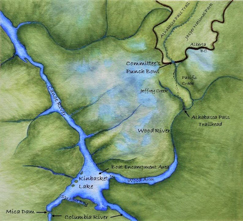
Being members of the Alpine Club of Canada Columbia Mountains Section, we knew about the work carried out on the B.C. side of the Athabasca Trail. To access the trail, hikers will need to leave from Sprague Bay by chartered boat that will take them upriver on the Wood Arm to the boat docking area near the bridge and from there, hike eight km to arrive at the Athabasca Pass Trailhead.
Downie Timber has a boat launch farther southeast that allows entry to the logging road across Kinbasket Lake, but this is not for public use.
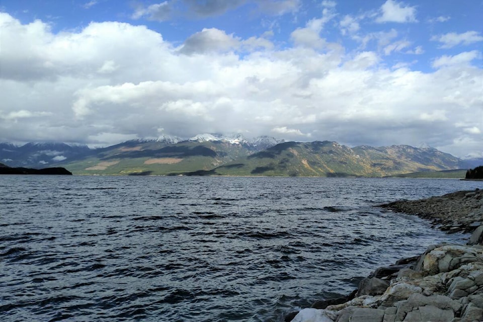
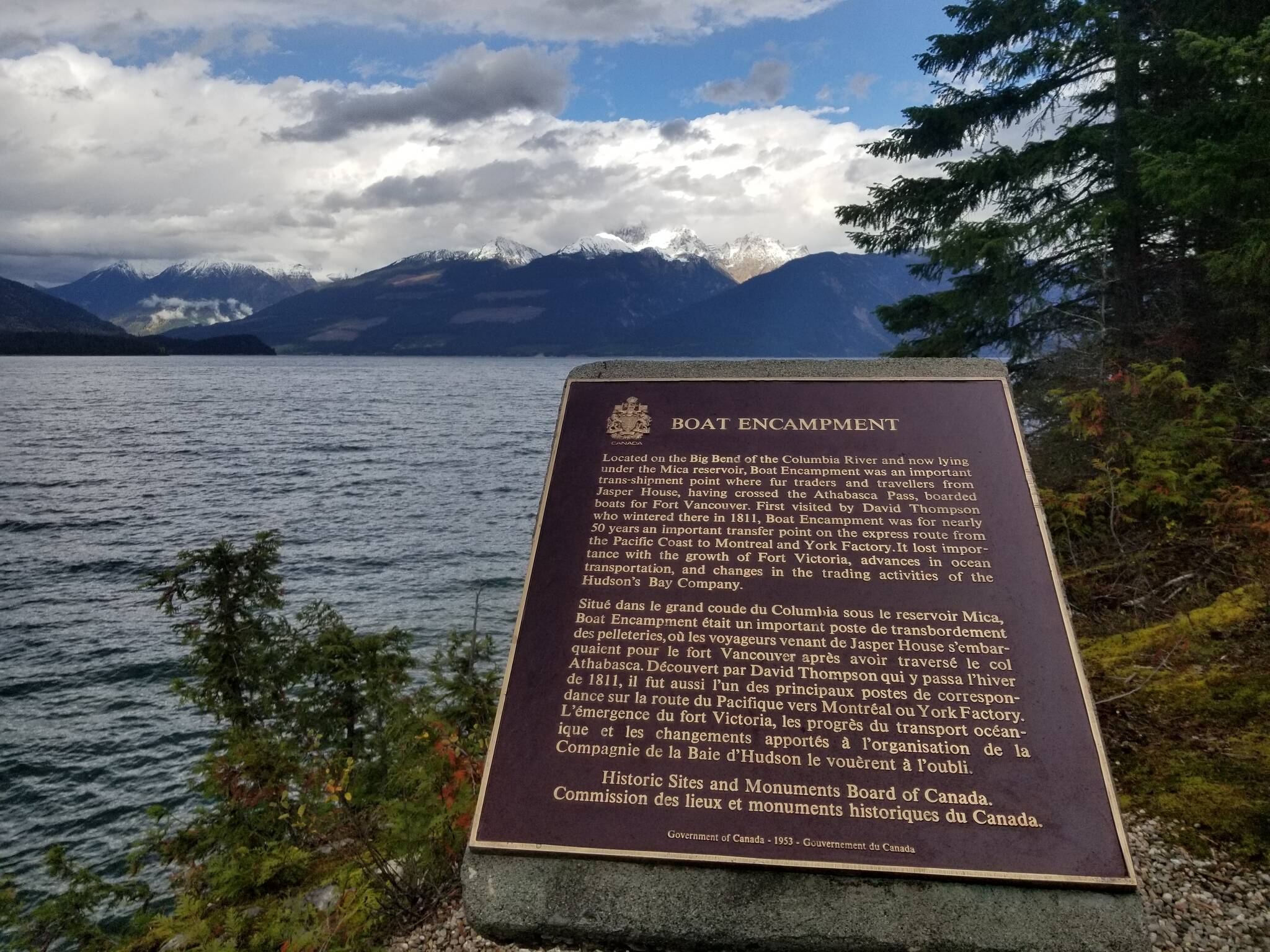
We followed a path from Sprague Bay campground to a plaque that stands on the rocky shore and points across the lake to the original site of Boat Encampment.
It is believed to have been between Wood Arm and Canoe River. The wind that October day bent branches of pine and spruce trees and made waves on the lake too big for kayaking.
Blue sky broke through clouds at intervals, sunlight lit up poplars and birches, setting off their gold colour. Clouds made patterns on the far shore. As I stood there reading the plaque, I thought of the events that happened over 200 years ago at Boat Encampment and on the Athabasca Trail.
I wanted to learn more. It looked different when David Thompson visited here in the 1800s.
Because of the Revelstoke and Mica dams, this area is flooded. Kinbasket Lake would have been smaller and the trees larger. I would have seen no evidence of logging on the green hills that lead down to the water as I did that day.
David Thompson, who worked for the North West Company, was a British-Canadian cartographer, surveyor and fur trader. Following the Whirlpool River Valley, he discovered the Athabasca Pass through the Rockies, guided by an Iroquois man named Thomas.
The discovery of the Pass opened an important trade route to the Pacific. After struggling over the Pass in deep snow, they reached the Columbia River during the winter of 1810- 11.Thompson and the men who accompanied him settled in where four valleys and three rivers come together. They built a wooden boat and named this place Boat Encampment.
Although birch trees were of huge sizes, the bark wasn’t thick enough for the usual birch bark canoe due to a milder climate on that side of the mountains.
Instead, they had to split cedar into thin boards and use roots to sew the boards together. This made a strong, light boat.
In spring, Thompson went on to travel the length of the Columbia River. He is known as ‘The Great Mapmaker’ for his accuracy and the high quality of his survey work.
Boat Encampment became a transfer location as furs were sent east to York Factory on the western shore of Hudson Bay and Montreal. Beginning at Fort Vancouver in Washington, voyageurs pushed their way north, up the Columbia River to Boat Encampment.
This was of course before dams were built on the river.
Deep gorges and waterfalls made the portages and boat linings incredibly difficult. Some of these trips were done in the fall rainy season with temperatures dropping and water freezing on the men’s clothing, which would not have been as lightweight or waterproof as today’s outdoor clothing is.
After their arduous canoe journey, Boat Encampment was a temporary stop-over where they put up tents and rested while waiting for the pack trains crossing the Rocky Mountains from the east.
Furs for Russia were transferred here and carried back down the Columbia River and on to the west coast bound for Sitka.
The artist Paul Kane spent time at Boat Encampment twice, in the fall of 1846 and 1847. After he left Toronto, he was permitted to ride along with the Hudson’s Bay Company couriers as they made their way to the west by land and water.
Kane sketched and wrote in his diary as he travelled to Fort Vancouver, Fort Victoria and along the West Coast, sketching and painting as he went to document the lives and customs of the Indigenous Peoples of the Northwest. He endured many hardships but crossing the Rockies before and after Boat Encampment was a particularly stressful part of his travels.
Each time the Athabasca Pass was deep with snow. The hike to the summit was a struggle from either direction for the men and the packed horses.
They stomped down the snow with their snowshoes to make a path and endured cold camps due to winter-like conditions. A small lake or tarn called Committee’s Punch Bowl sits at the Height of Land in the Athabasca Pass on the Continental Divide where it drains into the Columbia River on the west side and the Athabasca River on the east.
This is also the B.C./Alberta border. In the days of the Hudson’s Bay Company, they gave a toast here to the London Governor and Honourable Committee.
On the westward journey, once over the Athabasca Pass Kane and his party slipped and slid three thousand feet down “La Grande Cote” with their cargo and then continued along the shore of Wood River to the Columbia. On his return trip, the mud from the October rains slowed them down as their horses got stuck and had to be extricated.
When they ascended the Athabasca Trail on the steep Pacific slope, it got colder with the elevation gain and snow reached up to the horses’ bellies. They reached Committee’s Punch Bowl and pushed on through the dark until they came to a meadow about 16 kilometres below so the horses could forage for food.
Then they carried on as the valuable sketches, paintings and notes from Kane’s diary made it back safely to Toronto. In the years after, he worked from his sketches and finished many paintings that are treasured to this day. The Athabasca Trail the fur trading companies travelled to still exists.
Because the east side of it is in Jasper National Park, it is maintained.
On the west side of the Rockies, the trail can still be found but it is faint in places as fallen trees need to be removed. It was last cleared by the BC Wildfire Service in 2002 and some work was done on it in 2010.
The Alpine Club of Canada Columbia Mountains Section is working on restoring the trail to meet up with the Alberta side. Last summer, work parties were able to take the Downie Timber barge across Kinbasket Lake, and from there, drive and walk to the campground at the confluence of Jeffrey Creek and Wood River, as about half of the trail was cleared.
Work will continue this September so that eventually hikers will be able to enjoy the whole trail. Trees here and there have notches and blazes; telltale signs of people who came before. The Jasper National Park offers campsites with views of glaciers and peaks that won’t disappoint.
I’d like to go back to Sprague Bay for a second look, venture across Kinbasket Lake, and step ashore.
Although Boat Encampment is submerged, it would be meaningful to examine this place of historical importance that whispers of the past to anyone ready to listen.
@RevelstokeRevue
editor@revelstoketimesreview.com
Like us on Facebook and follow us on Twitter.