Last Thursday I went to Calgary. Yep. I went to Calgary, despite the fact the highways were chaos and the city was quickly being flooded. The occasion was the Sled Island music festival and there’s no way a bit of rain was going to stop me from seeing some of my favorite bands.
I checked DriveBC before leaving Revelstoke, fearing Heather Hill in Glacier National Park had come down and the highway was closed. It was all clear so I picked up my passenger Dana and off we went. We stopped at Tim Horton’s in Golden and the bad news started. I overheard a couple of truckers saying the highway was closed near Canmore. They were being told to go through Cranbrook.
Back on the road, we were stopped by a highway worker. Kicking Horse Pass was closed and the road around Canmore was bad. As in several days of closure bad. If we wanted to get to Calgary our best bet was going through Jasper because the Crowsnest Pass wasn’t looking good.
Dana suggested turning around but I wanted to push on. Sled Island is lots of fun, I had some friends I wanted to see and, worst case scenario, we spend the night in Fernie. At that point there was no indication Calgary was about to enter into a state of emergency.
So off we went south to Cranbrook. The creeks and rivers were raging everywhere. Near Fernie I got a text saying Highway 3 was down to one lane east of Sparwood and might close completely. The Elk River was raging and was perilously close to the highway. We kept going, holding onto our bladders and hoping for the best. We got to the closure and waited a while. Traffic started and stopped and started again. We made it past the flaggers and past the closure. We crossed into Alberta and stopped for a bathroom break and breathed a big sigh of relief.
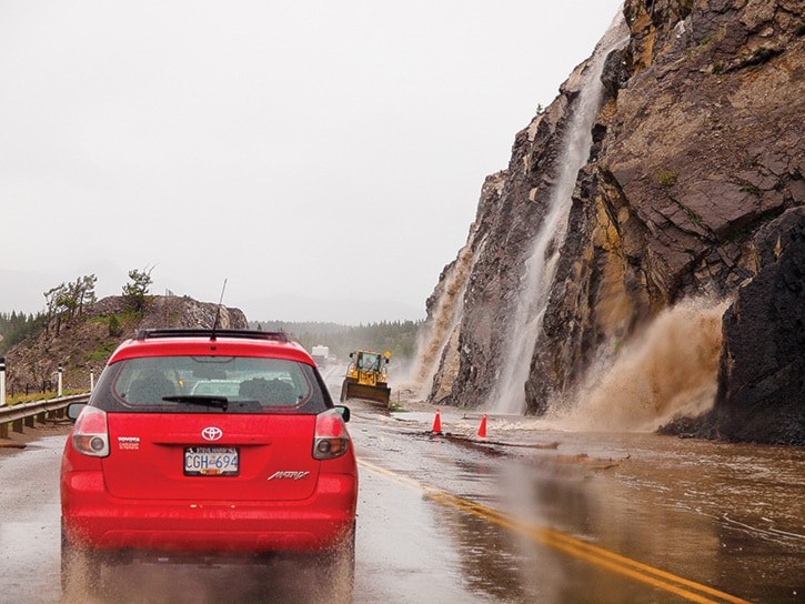
Somehow, in our rush to take a break, we didn’t notice what as up ahead. There was a series of cascading waterfalls crashing down some cliffs onto the road. I wanted to rest for a bit but there was no way I was taking any chances so we jumped into the car, drove through the flooded roadway and out of the mountains.
From there it was smooth sailing. Until High River. Just south, traffic stopped dead. Cars and trucks were making U-turns. We turned the music off and the radio on. The highway was flooded up ahead and completely closed. High River was underwater. We turned around and detoured through green fields under the endless, dark prairie sky. A tornado watch was in effect, so we watched the sky expecting the worst.
At around 8 p.m., after 11 hours of driving, we made it to Calgary. I dropped off Dana and made it to my friend Ryan’s hotel. Heading up MacLeod Trail, I crossed the Elbow River. What was normally a trickle was now a torrent.
The streets were wet but downtown was still alive with festival goers. I got my pass and was told one show had to change venues because of flooding. Everything else went on, and I had a good night catching a few bands.
The next morning, Ryan woke me up at 7 a.m. “I think the hotel is being evacuated,” he said. I packed my bags and we went downstairs. Turns out we jumped the gun. The power was out, but we could hang around. I went back to bed; Ryan went for a walk.
An hour later there was a knock on the door. We weren’t being kicked out yet, but there was free breakfast downstairs if I wanted it. Not being able to sleep, I went to get some food. Ryan came back and showed me some video he took of cars driving through flooded streets. I hopped on my bike and went to check things out.
A block to the east of our hotel, the street was covered in water. Heading towards the Bow River, I passed by police officers blocking off flooded streets. The traffic lights were out, but people were stopping at every intersection. The Bow River was a churning mass of brown water, overflowing onto some of the lower river-side pathways. The river was splashing onto the lower deck of the Centre Street bridge. On the upper deck, people were taking pictures of the chaos around them. Passage further east was blocked due to the floods.
I didn’t see much more because just then I got a text saying the hotel was being evacuated and we had to check out. I messaged a few friends looking for a place to stay. Two of them had also been forced from their apartments, but my friend Seth’s home way in the southwest was in a safe spot and he invited us in. By this point, the festival was canceled.
The drive there was tricky. MacLeod Trail flooded overnight, so took an alternate route past the Glenmore Reservoir, which had overflowed the day before resulting in the floods along the Elbow River. We arrived to a dry neighbourhood far removed from the flooding elsewhere.
Matt and Megan, two other refuges, were already there. We spent the day watching TV, drinking beer and playing Balderdash. We watched the footage I’m sure you’ve all seen – flood-ravaged Canmore, High River underwater, downtown Calgary deluged, the Saddledome inundated. It was strangely serene being there knowing what was happening elsewhere. We tried to get to a barbecue at another friend’s place, but the road closures made it impossible. We turned around and went back home.
On Saturday, after a good night’s sleep, I decided to head back to Revelstoke. The festival was continuing at random house shows around the city, but not knowing what it would be like getting back, it was best to leave.
I left the city on Highway 2, past High River, where army trucks were blocking access to the town. I turned onto Highway 22, which had been closed two days earlier. It was calm and beautiful, and other than one stretch where a bit of the road had collapsed, the drive was easy.
I made it through Crowsnest Pass without problems. The Crowsnest River, which had overflowed and forced nearby communities to evacuate, didn’t affect the highway. The road was still down to one lane east of Sparwood, but the risk to the road was essentially over. Past Sparwood, the Elk River had overflowed its banks, but didn’t reach the road. I saw vast fields that were flooded and houses that were partly underwater.
I had to detour through Kimberley and there was a minor delay at Skookumchuk, where the Kootenay River had eroded the shoulder right at the Springbrook Bridge. From there, it was an open road all the way back to Revelstoke. There were no trucks or RV traffic slowing down traffic. The Columbia River south of Golden was high enough to reach the CP Rail tracks. From Golden to Revelstoke, I passed four vehicles, and not a single one from Rogers Pass on down.
This makes me 0 for 2 on vacations last year. In March I was supposed to go the Asulkan Hut for three days of backcountry skiing but the trip got canceled because of a Pineapple Express system that led to dangerously high avalanche conditions. I have a trip home planned for the end of August, so lets hope Montreal doesn’t sink into the St. Lawrence River, or something like that.
I’ve never seen flooding like ths up close. Really, I was just a tourist amdist the unfolding distaster. I was always safe and I didn’t lose anything. Tens of thousands of people have lost their homes so I feel fortunate.