Ruedi Beglinger has seen first hand the effects of global warming. Guiding out of the Durrand Glacier chalet for 30 years, he's watched as the glaciers around his tenure have receded back, in some cases by almost a kilometre.
Where he used to have one ladder to get up a rock face, he now has three. Where it used to require climbing an ice face to reach the glacier, it's now an easy walk. Hazards exist where none did before. Where there used to be a glacier, there is now the Empire Lake hut — built last summer on bare rock as the latest addition to Beglinger's operation.
"If I think about this, I think the planet is losing its balance," he told me. "Glaciers are not just something up there that looks beautiful, it is a very important part of the existence of this planet."
I met with Beglinger at the end of his summer guiding season in the Selkirk Mountains north of Revelstoke. As has been reported, this year has been particularly hot, with a warm winter transitioning into an even hotter spring. Record temperatures were set in June when the thermometer neared 40 C in Revelstoke.
What has this meant for the glaciers in the Columbia Mountains? They've been shrinking for more than a century, but how did they hold up to this year's extraordinary weather?
To answer those questions, I spoke to Brian Menounos and Ben Pelto, two researchers at the University of Northern British Columbia. Menounos is an associate professor of geography and the Canada Research Chair in Glacier Change. Pelto is his PhD student. They're part of a team that studies glaciers throughout B.C.
In April, Menounos was the co-author of a paper on glacier change that said the Columbia Mountains could lose most of its glaciers by 2100 due to global warming.
I reached the two of them by phone last week, after they had completed their fall survey of the glaciers they monitor.
"The observed mass loss is 2.5 to three times what we've observed for the longer term – the 1985 to 2000 average," Menounos told me.
***
 A research team from the University of Northern British Columbia is studying the melt on four glaciers in the Columbia Basin — the Zillmer, the Nordic, the Conrad and the Kokanee. ~ Google Earth Image
Menounos' team studies four glaciers in the Columbia Mountains as part of a Columbia Basin Trust project to monitor ice loss. They are the Zillmer Glacier near Valemount, the Nordic Glacier northeast of Revelstoke, the Conrad Glacier, in the Purcell Mountains near the Bugaboos, and the Kokanee Glacier near Nelson.
Those four glaciers were chosen based on their elevation, aspect, and corresponding area. They're considered representative of glaciers throughout the region.
"You also want to get representative glaciers in the north, the mid portion and the south to tease out the relation of glacier change and climates," said Pelto.
To monitor the glaciers, they visit them twice a year — once in spring to measure the winter snowpack, and again at the end of summer to measure the melt. Poles up to six metres long are driven into the glacier in several places and they're measured to see how much melt occurred.
They also conduct an aerial LIDAR (light detection and ranging) survey over the glaciers that provides accurate surface elevation representations. "If you fly over two consecutive Septembers, you can subtract LIDAR elevation models and look at thickness loss," said Pelto.
Pelto wrote about his spring trip to the Kokanee Glacier on the blog From a Glacier's Perspective, which is run by his father Mauri Pelto, a glaciologist himself. It was Ben's third year studying the glacier since the surveys began in 2013.
The glacier extends from an elevation of 2,800 metres at the summit of Kokanee Peak down to 2,230 metres, where it ends at a lake that was uncovered over the past few decades due to glacier retreat.
On the blog, Pelto noted a few things about the winter season. First, it was warmer than usual and freezing levels were elevated. Secondly, the winter snowpack at high elevations was normal, but there was a noticeable point where freezing levels stood. While there was snow on the glacier, you could see bare ground not far below where there would normally be snow.
"With the warm winter, there was a magic elevation line where below that you had rain and above that you had snow, and that's where the variability came in with the glaciers," he said.
Finally, data from a nearby snow pillow site run by the B.C. River Forecast Centre showed an early and dramatic melt cause by the very warm spring. Pelto wrote that this winter could be a harbinger of things to come, "where increased winter temperatures lead to a higher snow line, lower snowpack at lower elevations, and near average snowpack at higher elevations."
When Pelto and his co-researchers returned to the Kokanee Glacier at the end of summer, they found a fairly dramatic loss of ice, estimated at between 1.5 to three metres. To put that into context, Meneunos had done a previous study comparing digital elevation models taken from the space shuttle in February 2000 with images produced by the B.C. government in 1985.
"The average we got for the province is that the glaciers were losing about three-quarters of a metre on average," he said. "Distributed over the glacier, that's about three-quarters of a metre of surface lowering."
On the more northern glaciers the team studied, the mass loss this summer was closer to the normal — about a metre of ice thickness was lost.
"I think it's mostly a change in rate in terms of the amount of melt occurring," said Pelto. "If your average year of late, in the past decade or two, is losing a half metre of ice a year, that's quite different to losing a metre and a half, or even up to three metres."
***
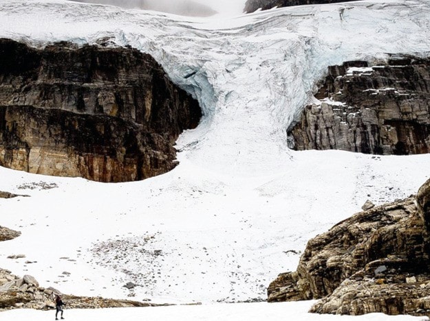
 Ruedi Beglinger laid out a big map of the Selkirk Mountain Experience tenure on my desk. He pointed to the numerous glaciers in his area and outlined how they all had shrunk. The lower elevation glaciers, like the Ruth Glacier, which was just a thin ice sheet stretching down to 1,800 metres elevation, had receded by almost a kilometre in the 30 years he'd been up there.
For glaciers at higher elevations, the loss wasn't so dramatic, but they were still losing ice slowly but consistently. He showed me pictures showing big moraines and boulder fields where there used to be ice — the glaciers are now in the far-off distance. In some places, he's started to track the change by marking rocks in the area.
Beglinger says he notices the changes in his day-to-day operations. He has to be more cautious of rockfall in the summer, and of crevasses in the winter. "You're going to see ice avalanches in places you haven't seen before," he said.
The glacial melt enabled him to build the Empire Lake Hut last summer on a patch of bare rock that used to be covered in ice. Empire Lake itself is also new.
"Last year there was just a small rock sticking up. Now it's an entire ridge," Beglinger said while showing me one photo.
Glaciers have been melting since the 1800s, when many reached their biggest size during the end of the Little Ice Age. The most obvious and best documented nearby example is the Illecillewaet Glacier, which used to be within an easy stroll of the railway in Glacier National Park, but has now receded by more than 1.5 kilometres since the last 19th century.
Parks Canada surveys the ice fields in Glacier National Park using satellite imagery every five years, and monitors winter snow accumulation and summer melt annually. A report is published every five years, with the most recent one, documenting findings up to the end of 2011, published in 2012.
That report says glacier coverage shrank by 12.7 per cent between 2000 and 2011. The average annual rate of change during that period of 1.16 per cent was higher than the rate calculated in the western Canada inventory from 1986 to 2006, "suggesting an increased rate of glacier retreat in the new millennium."
Parks Canada did not grant a request to interview one of their researchers and instead sent in an e-mail response to questions.
An interesting aspect about glacier loss is that there is a lag between warming and ice loss. While a glacier will lose mass during a warm summer, it could take decades for that warming to truly show itself. The toe of a glacier, located at lower elevations, will melt away, but the main body, generally located at higher elevations where there's more snow and less melt, will take longer to respond to warming. "There's an immediate reaction and there's a delayed reaction," said Menounos.
While difficult to determine, recent glacier melt is attributed to the rise of greenhouse gas emissions. A 2014 paper in the journal Science concluded that anywhere from 45 to 93 per cent of glacier loss from 1991 to 2010 was caused by an increase in human-caused greenhouse gas emissions.
"There's variability there but the only was you can count for that substantial mass change is greenhouse gases," said Menounos.
We could be bearing witness to the final years of glaciers in the Columbia Mountains. In a study published in the science journal Nature in April, Menounos and several co-authors wrote that in a worst-case scenario, glaciers in the Columbia Mountains could almost disappear by the end of the century. Even in their best case scenario, about 80 per cent of the region's glaciers will be lost. Barring a reversal of warming trends Only the highest and largest glaciers will remain. Revelstoke's iconic Mount Begbie glacier will likely disappear.
The impact could be substantial. Menounos' research is part of a project being conducted by the Columbia Basin Trust. The issue has also been studied by BC Hydro to see how they will have to adapt their operations. Glaciers act as stores of fresh water that provide melt water well into the summer, when streams could otherwise run dry. There will be less water as a result of glacier melt, but that is expected to be offset by increases in precipitation. However, the timing of stream flows could change substantially.
Then there's the aesthetic impact.
"One of the reasons I was drawn to British Columbia was to see permanent snow and ice and glaciers on the mountain landscape," said Menounos. "We're watching an important component of our heritage rapidly decline.
"I don't know what you would call Glacier National Park without the glaciers."
Watch this video produced by Ruedi Beglinger about the construction of Empire Lake Chalet, and the glacier melt that made it possible.