When the East Gate Landslide came down onto the Trans-Canada Highway last week, blocking the road for more than a day, it marked the second year in a row a slide there blocked the highway, and the third time since 2007.
So what is happening with the East Gate Landslide path on Heather Mountain that is causing it to deposit so much mud and debris on the highway?
The East Gate Landslide is a pre-historic landslide that was re-activated in 1997 along pre-historic fault lines, according to a 2006 geolical survey by Marc-Andre Brideau and Doug Stead of Simon Fraser University, and Rejean Couture of the Geological Survey of Canada.
“Most of the slope on that side of that valley is affected by ancient slope deformations,” said Couture in an interview. “What happened is a big failure inside the rock mass that was hanging there above the slope.”
The slide that was triggered stopped on a bench high up on Heather Mountain, however in the spring of 1999 enough debris built up to send the path further down the mountain.
“A huge volume of mass, a mix of soil, trees, boulder, blocks and water as well went down the slope and bull-dozed everything in its passage,” he said.
The slide path stopped at a lower bench, but when there is enough snow melt and heavy rain, it sends debris down well-formed channels to the Trans-Canada Highway.
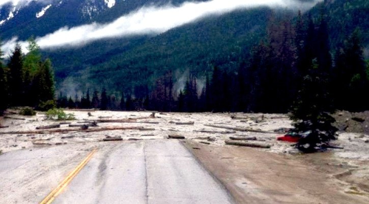
Normally only mud flows down to the highway but when the build-up is strong enough, it can bring rocks and trees with it. The debris flow can travel up to several metres per second, said Couture.
“If you look at the air photos, you have an elongated mass of debris that occupies about one-third of the entire slope,” said Couture. “This area is full of matter and debris - a mix of sand, boulders and trees. It’s standing there waiting to see rainfall events, snow melt, an increase of water to trigger debris flows”
To manage the landslide, Parks Canada built catchment basins at the base of two mud flow channels leading from the slide to the valley below. They also have built culverts and installed weather stations that monitor snowpack and precipitation, said Parks Canada spokesperson Jacolyn Daniluck in an e-mail.
This year, Parks Canada noticed the landslide becoming active in May and mud flow was observed in the channels leading to the highway. The heavy rain last week caused the flow to increase and by the morning of June 6, the catchment basins overflowed and the mud and debris covered 400 metres of highway about 3 metres deep.
“Parks Canada was aware that heavy rains were forecast and was ready with the necessary heavy equipment and staff to manage any possible highway closures and clean-up,” said Daniluck.
Couture said the key to preventing overflow is to make sure the catchment basins are managed and emptied in the fall or early-spring so that when the flows do start, there is enough room to capture all the trees and boulders that come down.
What is the potential of the East Gate Landslide? Can it result in a massive, catastrophic failure like the Frank Slide that buried a small mining town in the Alberta Rockies under 82 million tonnes of rock in 1903, killing more than 70 people?
Couture doesn’t think so. He said that slide was a sudden collapse of brittle rock with huge energy. The East Gate Landslide he described as more of a “big bulldozer that is moving slowly.”
As it stands, Parks Canada has no plans to expand the catchment basin, said Daniluck. “As always and in all seasons our focus is on motorist and worker safety so we close the highway when it is affected by slide activity or other extreme weather events.”