Revelstoke Bike to Work Week 2011 takes place from May 30 to June 5. Throughout May, the Times Review will publish four exclusive articles related to bicycle commuting in Revelstoke written by committee member Alex Cooper. This week’s article looks at what cycling infrastructure improvements are in Revelstoke’s future.
Imagine cycling from Arrow Heights or Columbia Park to downtown Revelstoke in a nice, wide bikelane, with trees lining one side and comfortably separated from cars in their own lanes.
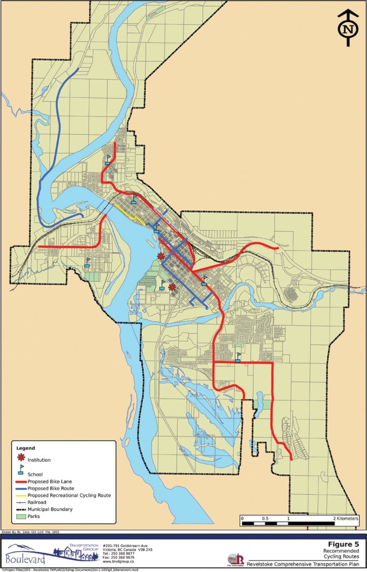
That’s what lies in store if the bicycle network plan laid out in the draft transportation plan comes to fruition. It’s an ambitious plan, with primary bicycle lanes stretching from Revelstoke Mountain Resort all the way to Columbia Park and the Big Eddy, as well as secondary bicycle routes throughout the downtown core and up Westside Road. A tertiary route would run through the Farwell neighbourhood, from the Big Eddy Bridge to Third Street West.
“We want to create a bike path across the city,” Brian Mallett, the city’s director of engineering and public works,
The plan hasn’t been without some controversy. The main bike lane through central Revelstoke would run alongside Victoria Road, if the transportation plan is drafted as is. However, according Mallett, this doesn’t necessarily mean putting bike lanes right along the roadway.
“It could be on a path beside the road if we can fit that in or maybe on the other side of the tracks and dealing with it that way,” said Mallett.
In Columbia Park, the route would follow Laforme Boulevard and Pearkes Drive. In the Big Eddy, the bike lane would go along Big Eddy Road. Through Arrow Heights, a lane would go along Airport Way, with a separate branch heading up Nichol Road and down Camozzi Road to the ski hill.
The secondary routes planned would service Southside along Moss Street and Eight Street. Central Revelstoke would see lanes along Third Street, Mackenzie Avenue and Pearson Avenue.
These secondary routes would not have dedicated lanes but would feature bicycle markings along the side of the road. The tertiary route along Douglas Street would simply contain road signs indicating it’s a cycling route.
Of course, all of this will not come cheap, with the total cost estimated at slightly less than $8 million. Primary bike lanes marked as high priority – from Arrow Heights, along Fourth Street and up Victoria Road would cost about $3.2 million. The secondary and tertiary routes would be much cheaper.
For example, a dedicated bike lane across the Illecillewaet Bridge could require building an expensive pathway along the side of the existing structure, said Mallett. “We don’t have the cash for that right now.”
According to the transportation plan, 30 per cent of trips in the summer are conducted on bicycle. “Based on the fact that bicycling is such a dramatic portion of the mode split in the summer indicates that Revelstoke has an active community with a strong desire to utilize cycling as a mode of transportation,” the plan states.
The total cost of the long-term plan is $109 million – if everything goes through. The investment in cycling infrastructure is comparatively small considering the number of people that bike regularly.